(Image is 45th and Speedway in the Hyde Park neighborhood, Austin, from
the Statesman )
(Amazing image is at 10th and Lamar, downtown Austin, from @jake_briz Twitter feed)
Well some weird stuff is going down in Texas. Wind and water. I think the aftermath of the double-barreled flooding events of this weekend aren't going away soon.
Texas is not unfamiliar with torrential rains and severe storms. What's unusual is the extent of this event, impacting Austin, Houston and Dallas areas. I am not sure what we will wake up to. So far our power is miraculously holding out, but a whole swath of central Austin is significantly underwater as I write, and it seems an even more serious event is unfolding in the Houston area at this moment.
1235 am CDT Tue may 26 2015

... Flash flood emergency for portions of Harris and Fort Bend
counties...

The National Weather Service in League City  has issued a

* Flash Flood Warning for...
  central Harris County in southeastern Texas...
  northern Fort Bend County in southeastern Texas...

* until 230 am CDT

* at 1235 am CDT... rain gauges have measured betwen 6 and 10 inches
  in this area. Additional heavy rain and significant flash flooding
  are occurring.

  This is a flash flood emergency for portions of Harris and Fort
  Bend counties.

* Some locations that will experience flooding include...
  Sugar Land... northwestern Missouri City... eastern Rosenberg...
  Stafford... Bellaire... West University Place... Richmond... Jersey
  Village... Hunters Creek Village... Bunker Hill Village... Piney Point
  Village... Spring Valley... Fourth Ward... town west... Pecan Grove...
  First Colony... Spring Branch west... neartown / Montrose... eastern
  Addicks park ten and greater heights.
Meteorologists are shaking their heads in amazement about this setup, and while local records are being broken left and right, it's not clear how to evaluate the wettest days ever across a whole state.
(Actually, since we get the occasional hurricane and tropical storm, this might not be the wettest ever. But it wouldn't be surprising if it's the wettest day not in hurricane season.)
(SEE UPDATE)
And simultaneously a surprisingly deep winter low off New Zealand, a heat wave in India, absurd warmth in Alaska and Yukon, (almost) unremitting drought in California... And this sort of thing keeps coming, doesn't it? It's hard to prove that it's already hitting the fan from climate change, but it sure is starting to look like normal weather is a thing of the past, isn't it? Teasing "weirdness" out of statistics is hard. But weird is weird, and too much weird is even weirder.
But one of the weirdest things happening is the very odd emerging El Nino pattern in the Pacific. You know, it's called El Nino as a reference to the Christ child, because it normally shows up abruptly around Christmas, not gradually over many months with a clear signal emerging in (boreal) spring!
And while there's still talk of a very strong El Nino, it hasn't arrived with full force.
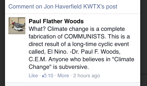
But what has arrived in full force is The El Nino Excuse. Never mind that the El Nino is shaping up just as weird as everything else has of late. It is a Thing. And it's an established excuse. So be prepared for everything that happens in the next couple of years, no matter how bizarre, to be blamed on El Nino.
Just had my first spotting of this inevitable denialist framing in the wild in the context of the Austin flood - this appeared in the Facebook stream of a local meteorologist:
Be ready for this one, mark my words.
Blame it on El Nino.
Other excuses are available, of course, if that one starts wearing thin.
UPDATE: By a wide margin,
John Nielsen-Gammon reports, it IS the wettest month in recorded Texas history and there are four more days to go.